
DJI Mavic 3 Enterprise Series: A Comprehensive Guide to Choosing the Best Suited Mavic 3 Enterprise Series Drone
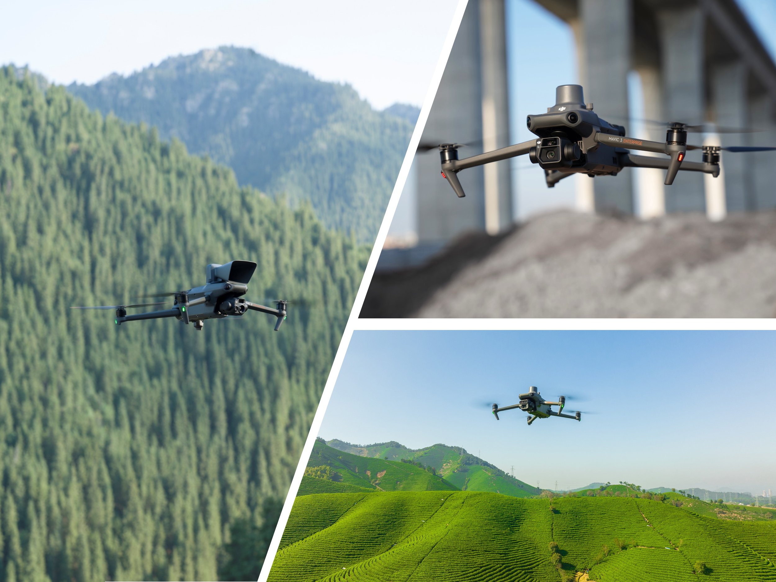
The DJI Mavic 3 Enterprise range features well-equipped drones capable of handling a variety of tasks, including surveying, inspection, thermal analysis, and multispectral imaging. To accomplish these tasks, the responsibilities are distributed among three main models: the DJI Mavic 3 Enterprise (M3E), DJI Mavic 3 Thermal (M3T), and DJI Mavic 3 Multispectral (M3M). Each drone serves different purposes, and it is important to tailor the right DJI Mavic 3 Enterprise Series drone to your unique circumstances. Some tasks may require multiple drones in and outside the Mavic 3 Enterprise range, such as pairing together both the M3E and M3T to provide precision mapping and thermal analysis capabilities to your operations.
All DJI Mavic 3 Enterprise Series drones share similar sizes, weights, and flight times, but they are distinguished by their 'payload'—the set of cameras each drone is equipped with. Different types and qualities of cameras provide each drone with unique capabilities suited for various tasks.
Each of the DJI Mavic 3 Enterprise Series drones can be equipped with additional modules such as the DJI Mavic 3 Enterprise Series Real Time Kinematics (RTK) Module for improved positioning or a DJI Mavic 3 Enterprise Series Speaker which is a loudspeaker used for applications like mustering or public safety broadcaster. The DJI Mavic 3 Enterprise Series also support third-party payloads through DJI’s PSDK system for custom modules, such as the CZI GL10 Gimbal Spotlight.
This guide aims to explore the differences between the DJI Mavic 3 Enterprise vs. DJI Mavic 3 Thermal vs. DJI Mavic 3 Multispectral drones.
DJI Mavic 3 Enterprise (M3E)

The DJI Mavic 3 Enterprise (M3E) excels in delivering high-quality photogrammetry data, perfect for precision surveying of expansive areas. This drone is indispensable for generating 2D maps with centimetre-level accuracy in diverse settings such as orchards, farms, power plants, new development sites, and mines. Additionally, the M3E is adept at 3D mapping and modelling, accurately recreating buildings and structures. This feature proves invaluable for projects requiring detailed models of building blocks, telecommunication towers, vehicles, and stockpile volumes.
The M3E uses a 4/3” CMOS 20MP Mechanical shutter main camera to take high-quality images. The large 4/3” sensor allows for a dense pixel count and a large pixel pitch, providing a larger area to capture light, making it exceptionally suitable for detailed modelling, even in challenging lighting conditions. Additionally, the mechanical shutter is a standout asset, allowing the capture rate between images to be faster (0.7 seconds) for improved data acquisition efficiency but most importantly, without distortion which is found in rolling shutters.
Mechanical Shutter vs. Rolling Shutter
Exclusive to DJI and the Mavic 3E and 3M is Time Sync, a specialised component embedded into the main camera. This technology synchronises the timing between the photo request and capture, significantly enhancing positional accuracy by minimising the 'lever arm effect'.
Utilising a Real-Time Kinematics (RTK) Module, the Mavic 3E achieves precise drone positioning. This system uses a combination of sensors to ensure exact positioning, crucial when accuracy down to a centimetre grade is required. Combined with a few Ground Control Points (GCPs) and Time Sync, the Mavic 3E can model any environment with exceptional accuracy. Furthermore, the Mavic 3E also supports Post Processed Kinematics, a drone surveying technique that corrects the location data of each captured image after it is collected and uploaded. You can learn more about how RTK works using our guide. Each drone allows you to connect to the DJI D-RTK 2 Mobile Base Station, or a custom network RTK service to access RTK corrections.
The M3E also includes a 1/2” 12MP tele camera, offering 7x tele-zoom and up to 56x hybrid zoom, which is ideal for detailed inspection tasks where thermal imaging is not required.
DJI Mavic 3 Enterprise & DJI Mavic 3 Thermal Tele-Zoom Camera
The Mavic 3E and the Mavic 3M both support real-time terrain awareness for more consistant overlap in 2D ortho and 3D oblique photogrammetry, as shown below:
DJI Mavic 3 Thermal (M3T)

The DJI Mavic 3T (M3T) is renowned for its advanced radiometric thermal imaging capabilities, ideal for scanning large areas and identifying thermal anomalies efficiently. Inspection work like monitoring hot spots on solar panels becomes flying over the solar farm and identifying which panels are malfunctioning at a fraction of the cost and time with the benefit of real-time aerial temperature analysis. When capturing thermal images, the temperature measurements per pixel are saved in the metadata of the thermal images, allowing stakeholders to analyse the temperature on the thermal images using special computer software such as the free-to-use DJI Thermal Analysis Tool.
The M3T also contains a 1/2” CMOS 48MP wide-angle camera, and similar to the M3E, the M3T also includes a 1/2” 12MP tele-zoom inspection camera for side-by-side inspection views allowing the operator to monitor multiple kinds of faults. Power line inspections become flying the drone along the line, identifying electrical hot spots, cracks in insulators, or other mechanical defects.
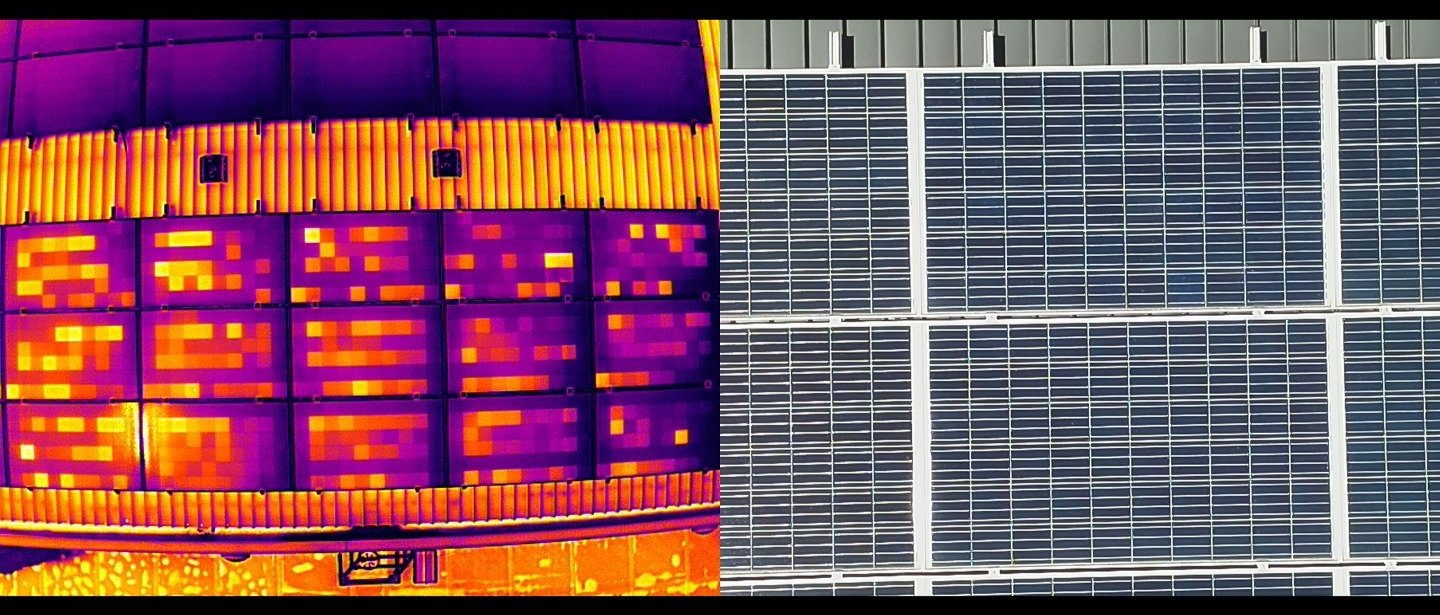
Solar Panel Inspection Work Using DJI Mavic 3 Thermal SBS View (IR + Tele)
When combined with an RTK module, drone position no longer purely relies on GPS. GPS can be prone to high interference sources like power lines, and without GPS the drone’s positioning can falter, but with the RTK module, the drone’s position is calculated from multiple sources, reducing the effect of noise. This improves the safety and accuracy of the drone flight which is essential when operating the M3T drone near critical infrastructure.
While the Mavic 3T does have a high-quality RGB main camera, this does not place it in the same surveying capabilities as the Mavic 3E, which unfortunately means that the M3T is not the perfect all-rounder. Firstly, the sensor size of the Mavic 3T’s 1/2” CMOS 48MP RGB Camera is significantly smaller than the 4/3” CMOS 20MP of the Mavic 3E’s main camera, this limits the amount of light captured by the Mavic 3T’s wide-angle camera. The 48MP camera is suitable for capturing detailed images and high-quality videos, but it falls short in quality when compared side-by-side to images captured by the Mavic 3E’s 4/3” 20MP. Time Sync also plays an important role between these cameras as well, where Time Sync isn’t found on the Mavic 3T, which means it can suffer from the ‘lever arm effect’ which affects the timing and positioning of images. The last big factor is the Mavic 3E’s Mechanical shutter, which removes the rolling shutter distortion effect when capturing images. The M3T uses an electronic shutter, which results in a larger capture interval between pictures (2 seconds). This means that the drone would need to be flown at a slower speed when mapping, hence not being able to cover a substantial area within a single flight. This ultimately means that the M3T is not recommended for comprehensive high-accuracy mapping and modelling, the M3E is much better suited for those tasks.
DJI Mavic 3 Multispectral (M3M)

The DJI Mavic 3 Multispectral (M3M) is a high-precision drone similar to the Mavic 3E in visual surveying capabilities, however, with one specific advantage. The M3M trades the x56 hybrid tele-zoom camera for 4 Specific Wavelength (i.e. multispectral) cameras, Near Infrared (NIR), Red Edge, Red, and Green sensors. These provide information on the invisible parts of light that can be critical in understanding situations like crop health stress.

Multispectral Cameras
A M3M outputs a visual map similar to other drones, but additionally combines its 4 multispectral sensors to layer information to generate indices such as NDVI (normalised difference vegetation index) and NDRE (normalised difference Red Edge), which in an agricultural setting help with monitoring crops showing early signs of stress in bands of light (NIR & Red Edge) that are outside what is visible to human eye. Typically, early signs of crop health stress are not visible to the human eye, but there are significant changes in reflectance values that can be observed in the Near Infrared and Red Edge bands of light that are invisible to the human eye. Multispectral data has a level of crop penetration as well, benefiting taller or denser crop like sugarcane and corn.

DJI Mavic 3 Multispectral NDVI + RGB SBS View (Real-Time)
Unique to the Mavic 3M is the sunlight sensor, which provides reference sunlight irradiance when capturing the multispectral data to calibrate reflectance values from improved reliability of results. Without the sunlight sensor, the result skews, as the time of day is important to how much light comes back to cameras.

DJI Mavic 3 Multispectral Sunlight Sensor
The Mavic 3M has the same 4/3” 12MP Mechanical RGB camera as the Mavic 3E, meaning that it gets all the same benefits such as time sync, mechanical shutter, quick capture rate, and a large sensor size. This allows it to provide survey grade mapping. It’s essential not to immediately jump to the M3M as the Mavic 3E includes the telephoto zoom camera, which gears the M3E more towards inspection work (in addition to its existing surveying capabilities), especially when needing a safe distance from a target. The Mavic 3M is a specialised device that best suits applications that require discrete vision of Near Infrared, Red Edge, Red, and Green bands for environmental monitoring or crop-health analysis.
Tech Specs
| Spec | Mavic 3E | Mavic 3T | Mavic 3M |
|---|---|---|---|
| Weight | 915g | 920g | 951g |
| Max Flight Time | 45 minutes | 45 minutes | 43 minutes |
| Main Camera |
4/3" CMOS Effective Pixels: 20 MP Shutter: Mechanical FOV: 84° |
1/1.32” CMOS Effective pixels: 48 MP Shutter: Electronic FOV: 84° |
4/3" CMOS Effective Pixels: 20 MP Shutter: Mechanical FOV: 84° |
| Time Sync | Yes | No | Yes |
| Thermal Camera | N/A |
Uncooled VOx Microbolometer Refresh Rate: 30Hz NETD: ≤ 50mk@F1.0 Resolution: 640x512@30fps |
N/A |
| Multi-spectral Cameras | N/A | N/A |
1/2.8-inch CMOS Effective pixels: 5 MP Sensors: Green (G): 560 ± 16 nm; Red (R): 650 ± 16 nm; Red Edge (RE): 730 ± 16 nm; Near infrared (NIR): 860 ± 26 nm; Shutter: Electronic |
| Telephoto Camera |
1/2" CMOS Effective pixels: 12 MP Shutter: Electronic FOV: 15° Native 8x zoom Hybrid 56x zoom |
1/2" CMOS Effective pixels: 12 MP Shutter: Electronic FOV: 15° Native 8x zoom Hybrid 56x zoom |
N/A |
| Uses |
High Accuracy Surveying & Photogrammetry Asset Inspection 3D Modelling Stockpile Analysis |
Thermal Analysis Asset Inspection Security Surveillance Search and Rescue |
Agriculture Environmental Monitoring |
| Supported Accessories |
DJI Mavic 3 Enterprise Series RTK Module DJI Mavic 3 Enterprise Series Speaker DJI RC Pro Enterprise 3rd-Party Accessories, e.g. GL10 Gimbal Spotlight |
DJI Mavic 3 Enterprise Series RTK Module DJI Mavic 3 Enterprise Series Speaker DJI RC Pro Enterprise 3rd-Party Accessories, e.g. GL10 Gimbal Spotlight |
DJI Mavic 3 Enterprise Series RTK Module DJI Mavic 3 Enterprise Series Speaker DJI RC Pro Enterprise 3rd-Party Accessories, e.g. GL10 Gimbal Spotlight |
Summary
Understanding the differences between the Mavic 3E, Mavic 3T, and Mavic 3M can initially be challenging. Each model is designed for specialised tasks: the Mavic 3E for surveying and inspection, the Mavic 3T for thermal imaging and inspection, and the Mavic 3M for multispectral imaging and surveying. Selecting the right drone depends on your specific needs, ensuring you have the right tool for the job.
We would highly recommend that you contact our knowledgeable solutions engineers to discuss what drone solutions would be best suited for your application(s). You can use the contact form below to get in touch with us.
You can also explore our DJI Mavic 3 Enterprise Series packages here: https://prismatech.com.au/commercial-drone-products/dji-mavic-3-enterprise-series
Our DJI Mavic 3 Thermal Packages can be seen here: https://prismatech.com.au/commercial-drone-products/dji-mavic-3-thermal-packages
Our DJI Mavic 3 Multispectral Packages can be seen here: https://prismatech.com.au/commercial-drone-products/dji-mavic-3-multispectral-packages