Image 1 of 6
 Image 2 of 6
 Image 3 of 6
 Image 4 of 6
 Image 5 of 6
 Image 6 of 6
DJI Matrice 400 Worry-Free Plus Combo
BUY NOW
The DJI Matrice 400 sets a new standard in professional drone operations. Built for critical missions and complex environments, it offers up to 59 minutes of flight time, a payload capacity of up to 6 kg, and advanced LiDAR-based obstacle avoidance for enhanced safety and situational awareness. With RTK positioning, O4 Enterprise transmission, and seamless compatibility with DJI’s latest payloads, the DJI Matrice 400 is ideal for surveying, asset inspection, emergency response, and autonomous workflows.
Key Features:
LiDAR + mmWave obstacle sensing
6kg Payload Capacity
IP55 Rating
59-minute Flight Time
DJI O4 Enterprise Transmission
20km max transmission range (CE)
Multi-Payload Support
This package includes the following:
1x DJI Matrice 400 Drone
1x 1-Year Enterprise Care Plus
1x DJI RC Plus 2 Enterprise Enhanced
1x TB100 Intelligent Flight Battery
1x BS100 Intelligent Battery Station
1x DJI RC Plus 2 sub2G SDR Module
1x WB37 Battery
1x DJI Matrice 400 Carrying Case
1x Rotating LiDAR Calibration Cover
1x DJI Matrice 400 2510F Propeller
1x DJI Matrice 400 Gimbal Damper
1x Screws and Tools
1x Cleaning Tools
1x Rubber Plug Screws (2×2)
1x E-Port V2 Rubber Port Cover
1x Front Propeller Holder
1x Rear Propeller Holder
1x USB-C to USB-C Data Cable
Complimentary Setup & Configuration
Pre-Order Now
DJI Matrice 400
Long-Endurance Drone Platform With Power-Line-Level Obstacle Sensing
Engineered for demanding enterprise missions, the DJI Matrice 400, the enterprise flagship drone platform, offers a class-leading 59-minute flight time, heavy-lift capability with up to 6 kg payloads, and precision obstacle sensing via rotating LiDAR and mmWave radar. Its support for O4 Enterprise Enhanced and Airborne Relay Video Transmission ensures robust communication in complex environments. With advanced features like Smart Detection, dual-spectrum imaging, AR overlays, automated workflows, and shipborne deployment, the Matrice 400 is the go-to solution for emergency services, utilities, surveying, and the AEC sector.
Endurance where it counts

Up to 59 mins forward flight time Up to 25 m/s flight speed
Extended Flight Time, High Speed Performance
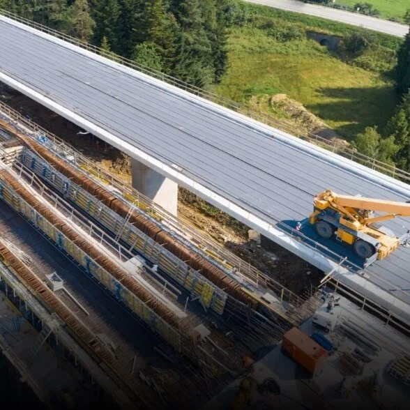
Matrice 400's flight capabilities are outstanding, offering up to 59 minutes of forward flight time even with a payload, and up to 53 minutes of hovering duration. These capabilities make it a reliable tool for long-duration and continuous operations such as search and rescue, firefighting, and large-scale mapping. It can also avoid large obstacles like buildings and mountains at flight speeds of up to 25 m/s.
Multi-Payload, Multi-Scene
Matrice 400’s strong payload capacity allows it to easily meet the demands of a wide range of applications. With a maximum payload capacity of 6 kg [2], Matrice 400 supports seamless switching between a single downward gimbal [8] and a dual downward gimbal [8]. It also features a third gimbal connector on the underside for additional flexibility. The aircraft is equipped with 4 external E-Port V2 ports [7], enabling simultaneous mounting of up to 7 payloads.

Depending on the task, Matrice 400 can be equipped with the Zenmuse H30 Series, L2, P1, S1 Spotlight, V1 Speaker, Manifold 3, or third-party payloads, thereby expanding its capabilities and unlocking the full potential of the DJI ecosystem.
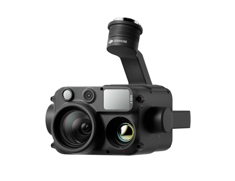
Zenmuse H30 Series
The Zenmuse H30 Series integrates five major modules—a wide-angle camera, a zoom camera, an infrared thermal camera, a laser range finder, and an NIR auxiliary light. Employing cutting-edge intelligent algorithms, it revolutionizes perception and imaging standards, transcending the limitations of day and night vision.

Zenmuse L2
Zenmuse L2 integrates frame-based LiDAR, a self-developed high-accuracy IMU system, and a 4/3 CMOS RGB mapping camera, providing DJI multi-payload drone platform with more precise, efficient, and reliable geospatial data acquisition.

Zenmuse P1
Zenmuse P1 integrates a full-frame sensor with interchangeable fixed-focus lenses on a 3-axis stabilized gimbal. Designed for photogrammetry flight missions, it takes efficiency and accuracy to a whole new level.

Zenmuse S1
Zenmuse S1 is DJI's first spotlight designed for multi-payload drone platforms. Utilizing the LEP technology, it offers high brightness and long illumination distance, and supports multiple lighting modes. This makes it ideal for public safety, emergency rescue, inspection, and other nighttime operations.

Zenmuse V1
Zenmuse V1 is DJI's first loudspeaker designed for multi-payload drone platforms. It boasts high volume and long broadcast distance, and supports multiple broadcast modes, making it ideal for scenarios like public safety, emergency rescue, and more.

Manifold 3
Manifold 3 packs an impressive 100 TOPS of computing power into a compact unit weighing about 120 g. It can be mounted onto Matrice 400 drone platform, optimizing efficiency across various operational missions with its robust processing.
Flight Time
Estimate the Matrice 400’s flight time based on payload configuration.

Estimate the Matrice 400’s flight time based on payload configuration.
Safe and Reliable Flight
Built for Challenging Conditions
Matrice 400 has a protection rating of IP55 [9], allowing it to operate reliably in challenging conditions including heavy dust or rain. It also maintains stable performance across temperatures from -20° to 50° C (-4° to 122° F), delivering consistent results in both hot and cold conditions.


Power-Line-Level Obstacle Sensing
The Matrice 400's advanced obstacle sensing system integrates rotating LiDAR, high-precision mmWave radar, and full-color low-light fisheye vision sensors, pushing detection capabilities to unprecedented levels. The system detects even small obstacles like high-voltage power lines across mountainous terrain — even in darkness. It can penetrate rain and fog to sense its surroundings, providing enhanced safety in challenging weather conditions.
Robust Video Transmission

O4 Enterprise Enhanced Video Transmission System
Thanks to the ten-antenna system on the aircraft and the high-gain phased array antenna system on the remote controller, the O4 Enterprise Enhanced Video Transmission System can achieve image transmission up to 40 km (20km according to CE/RCM specifications in Australia). Matrice 400 also supports the sub2G frequency band, and when equipped with two DJI Cellular Dongle 2, it can automatically switch to the better available carrier network, providing a more stable signal even in urban interference environments or remote regions.

Airborne Relay Video Transmission
Matrice 400 has a built-in video transmission relay module. With this setup, one Matrice 400 can serve as a relay drone, flying high to provide relay signals for another Matrice 400 operating at a greater distance. This capability significantly extends the transmission range, making it ideal for search and rescue tasks as well as inspections in mountainous areas.
Aircraft Fusion Positioning
The omnidirectional sensing performance brought by rotating LiDAR, high-precision mmWave radar, and full-color low-light fisheye vision sensors provides Matrice 400 with strong positioning capabilities. It can fly stably close to glass-facade buildings or wind turbine blades and safely return from building edges, mountain bases, or bridge sides even when the return point has not been updated.
Full-Color Vision Assist
The four full-color low-light fisheye vision sensors on the aircraft provide Full-Color Vision Assist to ensure safer flight.
Enhanced Intelligence and Efficiency
Smart Detection
With Zenmuse H30 Series' visible and thermal imaging, Matrice 400 can detect vehicles, vessels, and subjects during search and rescue operations or routine flights. It also supports switching to other models, enabling the expansion of application scenarios. Additionally, it supports high-res grid photos and features powerful tracking capabilities.
Smart AR Projection
-
Durіng tаѕkѕ ѕuсh аѕ роwеr grіd іnѕресtіоn, thе оbѕtасlе ѕеnѕіng ѕуѕtеm аutоmаtісаllу dеtесtѕ frоntаl wіrе оbѕtасlеѕ аnd dіѕрlауѕ еаѕіlу rесоgnіzаblе АR lіnеѕ оn thе rеmоtе соntrоllеr’ѕ ѕсrееn, mаkіng thе ѕurrоundіng еnvіrоnmеnt сlеаr аt а glаnсе аnd еnѕurіng ѕаfеr flіght.
-
When operating during the day or night in urban regions, the remote controller can display the names of buildings and landmarks in real-time, marking core roads with prominent lines.
-
Real-time route preview is available for the drone during RTH, obstacle sensing, and FlyTo operations. During landing, the AR Aircraft Shadow can be displayed to help operators confirm the landing location.
-
Without modeling, you can mark points on the remote controller screen to obtain subject locations, draw lines to measure distances between multiple points, and outline areas to calculate their size. Measurement results can be synchronized to the DJI FlightHub 2 to enhance team efficiency.
Real-Time Terrain Follow
Matrice 400 supports Real-Time Terrain Follow flight in any horizontal direction. This feature can be enabled during both manual flight and automated flight routes, ensuring stable relative height to the ground.During large-scale search and rescue operations, the size of ground subjects can be kept consistent on the remote controller screen, reducing the need for frequent zoom adjustments and improving efficiency. During mapping missions, a consistent ground sampling distance (GSD) can be maintained to obtain high-precision mapping data.
Takeoff and Landing on Ships
To address the needs of offshore operations such as maritime patrol and wind turbine inspection, Matrice 400 is equipped with the capability to take off from and land on ships, supporting takeoff from stationary vessels and landing on moving vessels. By detecting landing point patterns on the deck, it can achieve safe and precise landings.
Intelligent Flight Modes
-
Activate cruise control mode to pilot the drone in a specific direction without constantly pressing the control sticks, making long-distance flights or linear inspections easier.
-
Іn еmеrgеnсіеѕ оr dіѕаѕtеrѕ, thе drоnе саn аutоmаtісаllу аdјuѕt іtѕ flіght раth аnd ѕрееd bаѕеd оn thе ѕurrоundіng еnvіrоnmеnt, аllоwіng іt tо rеасh а dеѕіgnаtеd lосаtіоn wіthоut mаnuаl аdјuѕtmеntѕ.
-
Ѕmаrt Тrасk аllоwѕ fоr рrесіѕе ѕubјесt роѕіtіоnіng аnd аutоmаtіс zооm аdјuѕtmеntѕ, аllоwіng уоu tо ѕwіtсh bеtwееn ѕubјесtѕ еаѕіlу. Іt саn аutоmаtісаllу rеасquіrе а ѕubјесt еvеn іf оbѕсurеd brіеflу.
-
РОІ еnаblеѕ соntіnuоuѕ оbѕеrvаtіоn аnd 3D mоdеlіng оf buіldіngѕ whіlе оrbіtіng а dеѕіgnаtеd аrеа, grеаtlу еnhаnсіng thе еffісіеnсу оf fіхеd-роіnt оbѕеrvаtіоn аnd mоdеlіng tаѕkѕ.
Easier Automated Operations
Power Line Follow With Zenmuse L2
When equipped with the L2 LiDAR system, Matrice 400 can perform automated power transmission and distribution line following flights. It uses the rotating LiDAR to detect obstacles in real time and automatically bypasses crossing lines.
Slope Route & Geometric Route
Matrice 400 supports the planning and execution of slope and geometric routes via DJI Pilot 2 or DJI FlightHub 2. Whether conducting detailed aerial surveys of building facades, slopes, or other inclined surfaces, or collecting mapping data of individual buildings or structures, Matrice 400 can quickly plan slope or geometric routes to efficiently acquire high-precision data.
Software Designed for Industries
DJI FlightHub 2
Specifically for the Matrice 400, DJI FlightHub 2 has been upgraded to enable cloud-based remote control, allowing operators to control the aircraft's flight attitude and official payloads, as well as to perform remote takeoff, landing, and Live Flight Controls. In addition, it supports a wide range of flight route planning functions, including slope routes, geometric routes, and other advanced route types. During multi-drone operations, operators can remotely synchronize and display multiple livestreams across screens, creating a new, efficient air-ground integrated operation experience.
* Users who purchase Matrice 400 and bind it to FlightHub 2 upon activation will receive allocated live streaming minutes, map imagery quotas, and cloud storage space.
DJI Terra
DJI Terra is a 3D model reconstruction software that has photogrammetry as its core technology. It supports accurate and efficient 2D and 3D reconstruction using visible light data, as well as point cloud data reconstruction and processing with DJI Zenmuse L2. DJI Terra is an ideal match for DJI Matrice 400 and its payloads. It works in conjunction to build a complete application solution that caters to vertical scenarios such as land surveying and mapping, power line inspection, emergency response, construction, and forestry.
DJI Modify
DJI Modify provides intelligent 3D mesh and point cloud model editing. When paired with the Matrice 400 and DJI Terra, it can create an integrated solution covering aerial surveying, modeling, model repair, and sharing.
Open Developer Ecosystem
Intelligent Algorithm Developer
Provides the necessary model training tools and third-party developer certification process to access onboard computing capability, helping to expand new application fields for drones.
PSDK
The newly upgraded E-Port V2 supports USB 3.0 high-speed payload communication and delivers up to 120 watts of power per port. The E4 port of the E-Port V2 can be expanded into four payload ports via the E-Port Hub expansion plate, unlocking broader application scenarios and greater potential for the Matrice 400.
MSDK
Mobile SDK 5 simplifies the development of apps to control the Matrice 400. It comes with fully open-source, production-level code samples with core modules adapted from DJI Pilot 2, guaranteeing high reliability.
Cloud API
With DJI Pilot 2's built-in Cloud API (MQTT-based protocol), you can directly connect the Matrice 400 to third-party cloud platforms. Access the drone's hardware, video live-stream, and photo data without having to develop an app.
Open Data Access
Developers can leverage payload, LiDAR, mmWave radar, and vision sensor data interfaces to build innovative applications and expand the DJI ecosystem.
User Data Security

-Media Data Encryption -Local Data Mode -One-Tap Clear Logs -AES-256 Video Transmission Encryption -Cloud API
Application Scenarios

Public Safety

Power Line Inspection

Geographic Information

Oil and Natural Gas

Renewable Energy

Water Conservation

Maritime