
DJI Zenmuse L3: Long-Range Aerial LiDAR, and What It Takes to Run One
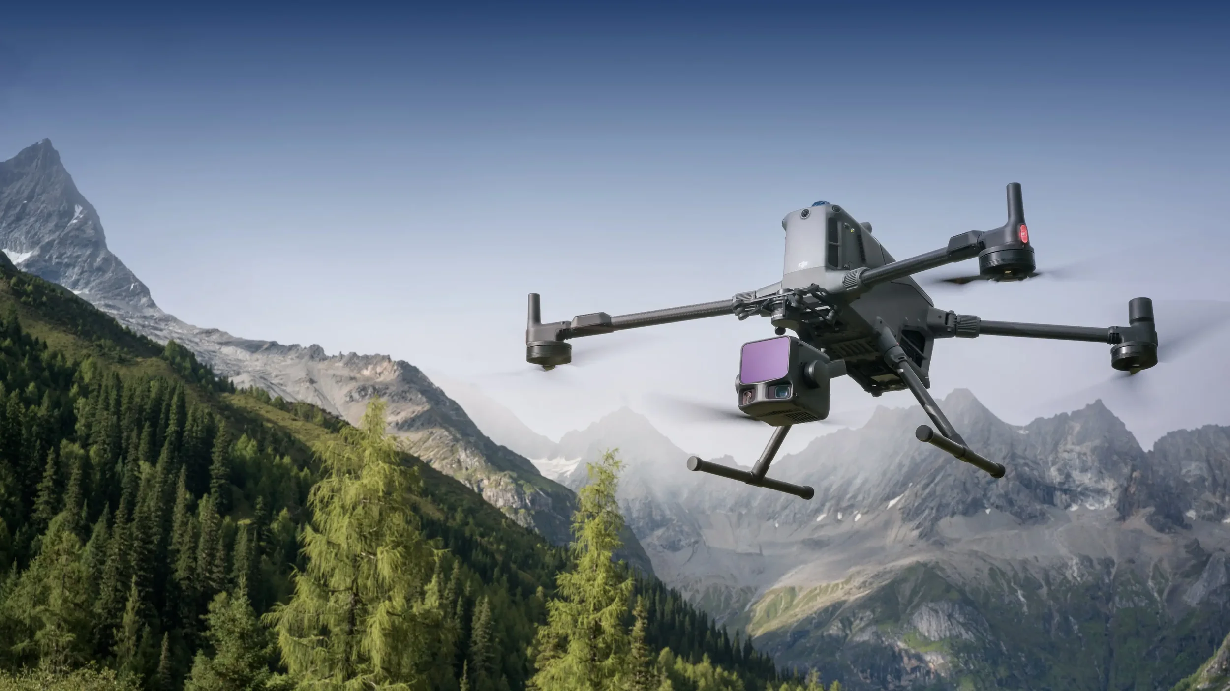
The DJI Zenmuse L3 is DJI's first long-range aerial LiDAR system, and the first that genuinely competes with survey payloads costing several times as much. It can detect targets up to 950 m away, scan up to 2 million points per second and capture up to 16 returns, while delivering 3 cm vertical accuracy at 120 m and covering up to 100 km² per day. Its dual 100 MP wide-angle cameras nearly align their field of view with the LiDAR swath, enabling the imagery to use nearly the same efficient side overlap as the LiDAR data, reducing the number of flight lines required.
It also only flies on one aircraft, needs a dedicated gimbal connector, and its headline productivity figure is calculated at an altitude that Australian operators cannot reach without a CASA approval.
This guide covers what the L3 does, what it takes to get the accuracy DJI publishes, and what changes when you operate it in Australia. If you are weighing an L3 against a mobile scanner, a manned survey, or an existing L2 fleet, the sections below are ordered the way that decision actually gets made.
The short version
- Matrice 400 only. The L3 is not compatible with the M300 or M350. It is designed exclusively for the M400 and requires the dedicated L3 single-gimbal connector to be connected to the aircraft’s E1 port to maintain mapping accuracy.
- 3 cm vertical, 4 cm horizontal at 120 m AGL (RMSE), degrading to 5 cm and 7.5 cm at 300 m. Enough for 1:500, 1:1000 and 1:2000 mapping.
- 950 m range is real but conditional. That figure is the centre of the field of view at 100 kHz on 10% reflective targets. At the edge of the swath it is 650 m.
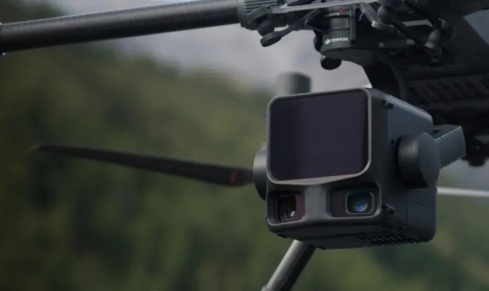
- Dual 100 MP cameras give a 107° combined field of view, so you produce a DOM and a DEM from one flight instead of two.
- The 100 km²/day figure assumes 300 m altitude. In Australia that needs a CASA approval to operate above 400 ft, and potentially a BVLOS/EVLOS approval too.
Jump to
DJI's official Zenmuse L3 introduction, released November 2025.
A good fit if you
- Run corridor, terrain or forestry mapping at scale
- Need bare-earth models under vegetation
- Already operate, or are buying into, the Matrice 400
- Deliver to 1:500 or coarser mapping scales
- Have, or can obtain, altitude and BVLOS approvals
Probably not yet if you
- Fly an M350 or M300 and are not replacing the airframe
- Need sub-centimetre accuracy for structural or as-built work
- Map small, tight sites where a terrestrial scanner wins
- Are looking for a general-purpose inspection payload
The Zenmuse L3 only flies on the Matrice 400
This is the first thing to settle, because it changes the L3 from a payload purchase into a platform decision.
The L3 is compatible with the DJI Matrice 400 and nothing else. It will not mount to a Matrice 350 RTK or a Matrice 300 RTK. There is no adapter that changes this. The L3 has higher power consumption, the M300/M350 gimbal power supply does not meet the requirement
It also requires the Zenmuse L3 single gimbal connector, which is specific to this payload. That connector has to be fitted to the E1 port on the underside of the aircraft.
The reverse is also not supported. The Zenmuse L3 single-gimbal connector is dedicated to the L3 and is not a general-purpose payload mount. DJI states that installing other payloads may reduce performance. For example, an H30T may exhibit slight video shake. The P1 should likewise be installed using a standard single gimbal connector that the M400 comes supplied with; mounting the P1 on the L3 connector is unsupported and may reduce mapping accuracy.
If you currently fly an M350 with a Zenmuse L2, moving to the L3 is a fleet transition, not a sensor upgrade. Budget for the aircraft, new flight batteries, new charger, and potentially consider the D-RTK 3 Multifunctional Station if you do not already run one. You can use the M400 with a network RTK service, 3rd party base station (via NTRIP caster hotspot), or consider running PPK for the L3 in DJI Terra. Talk to us before you scope the project and we will map out the full configuration.
950 m range at the centre of the swath, 650 m at the edge
The L3 uses a 1535 nm laser, a longer wavelength than the L2, which allows much higher pulse energy while staying within Class 1 eye-safe limits under IEC 60825-1.
Longer wavelength plus a tighter beam is where the range comes from. Beam divergence is 0.25 mrad, producing a spot roughly 41 mm across at 120 m and 86 mm at 300 m. That is around one fifth the spot size of the L2 at the same distance, which is what drives both the extra range and the improved penetration through vegetation.
Range is not a single number. It scales inversely with pulse rate, and it drops toward the edges of the field of view. The table below is the figure you should plan flights against.
| Pulse rate | Centre of FOV | Edge of FOV | Recommended altitude | Returns |
|---|---|---|---|---|
| 100 kHz | 950 m | 650 m | Up to 500 m | 4, 8 or 16 |
| 350 kHz | 700 m | 500 m | Up to 300 m | 4, 8 or 16 |
| 1000 kHz (1 MHz) | 400 m | 280 m | Up to 100 m | 4 or 8 |
| 2000 kHz (2 MHz) | 290 m | 200 m | Up to 50 m | 4 |
On highly reflective surfaces the ceiling is much higher, up to 2000 m at 80% reflectivity and 100 kHz. Minimum effective detection distance is 10 m, so the L3 is not a close-quarters sensor.
Units ship with maximum detection range limited to 900 m. Unlocking beyond that requires going through DJI support or an authorised DJI Enterprise dealer. If your work needs the full range, raise it with us at the point of purchase rather than after delivery.
Sixteen returns, and more points reaching the ground
At 100 kHz and 350 kHz the L3 records up to 16 returns per pulse. Each return is another surface the pulse found on its way down, so in forested terrain the first returns land on canopy, intermediate returns catch understorey, and the last returns reach ground.
Combine that with the smaller spot and higher single-pulse energy and you get the L3's real advantage: ground point density. More of the emitted energy squeezes through gaps in the canopy and comes back, so the ground surface underneath is described by more points and fewer holes. That completeness is what makes surface fitting and terrain reconstruction reliable, rather than something you patch by hand afterwards.
For forestry, vegetation management and any terrain mapping under cover, this is the single strongest reason to choose the L3 over the previous generation.
Two 100 MP cameras mean one flight, two deliverables
The L3 carries two 100 MP mapping cameras angled 45° apart, giving a combined horizontal field of view of 107°. In comparison, the L2 managed 84° from a single sensor.
That wider swath is not just about covering more ground. It changes what a single flight produces. Because the RGB coverage is substantially wider than the LiDAR swath, a flight planned with 20% LiDAR side overlap still provides approximately 49% side overlap between the RGB images. This allows a complete digital orthophoto map (DOM) and LiDAR-derived digital elevation model (DEM) to be produced from the same sortie.
However, 49% image side overlap is an efficiency-focused setting rather than the optimum for every photogrammetry project. When the RGB imagery is the primary photogrammetric dataset, we recommend greater overlap for stronger tie-point redundancy and more robust reconstruction. DJI’s default visible-light mapping settings are 70% side overlap and 80% forward overlap, with additional overlap recommended over complex or undulating terrain.
Each of the L3’s two 100 MP RGB mapping cameras uses a 4/3 CMOS sensor, a 28 mm-equivalent lens with an adjustable f/2.0–f/11 aperture, and a mechanical shutter rated for 500,000 actuations. The system delivers an average ground sample distance of approximately 3 cm/pixel at a 300 m nadir flight altitude.
Choosing between 100 MP and 25 MP
The cameras run in two modes and the choice comes down to flight altitude.
- 100 MP (high resolution) at 12288×8192 (12K). More detail and more storage. For the same GSD it lets you fly higher, so use it above 150 m. It is worth noting that the 12K mode has a slower minimum capture interval of 1s.
- 25 MP (high sensitivity) at 6144×4096 (6K). Larger effective pixels, better signal-to-noise, less storage, quicker capture rate (0.5s minimum interval). Use it at or below 150 m, and in poorer light.
Keep 20 m of standoff. Maintain at least 20 m between the L3 and the ground or subject. At shorter distances, parallax between the two RGB cameras can produce a visible seam in the stitched LiveView.
Brightness can differ left to right in the live view. Each camera meters independently to optimise its own exposure. If the two halves of the scene are lit differently you will see it on screen. The final imagery is still exposure-matched.
Video uses one camera only. When recording video the L3 uses the right-hand RGB camera, facing the LiDAR.
3 cm vertical at 120 m, 5 cm at 300 m
These are the numbers that decide whether the L3 fits your deliverables. DJI publishes them as RMSE from controlled testing, and they support mapping at 1:500, 1:1000 and 1:2000.
| Flight altitude | Vertical accuracy | Horizontal accuracy |
|---|---|---|
| 120 m | 3 cm | 4 cm |
| 150 m | 3.5 cm | 5 cm |
| 300 m | 5 cm | 7.5 cm |
| 500 m | 10 cm | — |
Point cloud thickness, which is the noise band around a flat surface, is 1.2 cm at 1σ from 120 m and 2 cm at 1σ from 300 m. That is roughly half the L2's figure, and it is what makes fine surface fitting and volumetric analysis viable. For a 6σ figure, multiply by six.
Ranging performance underneath those system figures is ±10 mm absolute accuracy with better than 5 mm repeatability at 1σ.
What it takes to actually hit those numbers
DJI's figures come from a specific test configuration. Reproducing them in the field means reproducing the configuration. Treat this as a pre-flight checklist:
- Matrice 400 linked to a position-calibrated D-RTK 3 Multifunctional Station
- Route planned in DJI Pilot 2 using Area Route with Calibrate IMU enabled
- Linear scanning mode
- Flight speed 15 m/s, gimbal pitch -90°
- Straight route segments kept under 3300 m
- Post-processed in DJI Terra with Optimize Point Cloud Accuracy enabled
- Checkpoints on exposed hard ground conforming to a diffuse reflection model
The POS system underpinning all of it updates at 200 Hz with GNSS at 5 Hz. Post-processed attitude error is 0.02° in yaw and 0.01° in pitch and roll. With an RTK fix, positioning accuracy is 1.0 cm + 1 ppm horizontally and 1.5 cm + 1 ppm vertically.
Three scanning modes, matched to three types of job
Mode selection has more influence on your deliverable than almost any other setting, and each one exists for a distinct class of work.
Linear — terrain and corridor mapping
An 80° horizontal by 3° vertical swath. Point distribution is even and predictable, which is what you want when accuracy and consistency matter more than seeing an object from multiple angles. This is the mode DJI uses for its published accuracy figures, and the default for high-accuracy terrain mapping.
Star-shaped — forestry and dense urban
An 80° by 80° field of view that trades a little accuracy for multiple scan angles. Hitting the same ground from several directions dramatically improves the odds of finding a gap through canopy or between buildings. Use it where penetration is the constraint.
Non-repetitive — towers and complex structures
Also 80° by 80°, with a scan pattern that never repeats, so coverage accumulates and fills in over time. Best for transmission tower reconstruction and other structures where you need complete geometry on a complex three-dimensional object rather than an even ground surface.
Previewing the result before you fly
Pilot 2 can produce a Point Cloud Output Estimate that helps with understanding expected density. These estimates are based on the route parameters, including altitude, speed, side overlap, scanning mode, pulse rate and expected target reflectivity. It returns flight band centre scatter plots and a minimum density plot.
This is worth using on every job. It is far cheaper to discover a density problem at the planning stage than after a mobilisation.
What 100 km² per day means for an Australian operator
DJI's headline productivity figure is up to 10 km² in a single flight and up to 100 km² per day. Both are achievable, but the assumptions behind them deserve reading carefully before you build a business case.
The 100 km² figure assumes flat terrain, 300 m nadir flight altitude, 20% side overlap, 17 m/s flight speed, and six hours of effective flight time.
Three hundred metres is roughly 985 ft. Standard operating conditions under CASA Part 101 limit remotely piloted aircraft to 400 ft AGL. Six hours of effective flight time over 10 km² sorties also means sustained operations beyond visual line of sight.
Operating above 400 ft. Reaching the altitudes where the L3 is most efficient requires a specific CASA approval beyond a standard ReOC.
BVLOS/EVLOS. Long corridor and area work at these speeds may require a BVLOS/EVLOS approval.
Neither is unusual for established survey operators, and neither is a reason to avoid the L3. But if you plan around 100 km² per day and hold only standard operating approvals, your real-world figures at 120 m will be substantially lower. Requirements change, so confirm the current position with CASA or with us before committing to a delivery programme.
None of this makes the L3 a poor performer at legal default altitudes. At 120 m you still get 3 cm vertical accuracy, impressive vegetation penetration, and 1.2 cm point cloud thickness, which is better than the previous generation managed at any altitude. The point is simply to plan against the altitude you are actually approved to fly.
Australian mapping deliverables commonly use GDA2020 geographic coordinates or the projected MGA2020 grid, with elevations often required in the Australian Height Datum (AHD). By default, the D-RTK 3 uses WGS84 coordinates in Broadcast Mode and an ellipsoidal height, not an AHD height.
Where the data goes: Pilot 2, Terra and Modify
The L3 records raw point cloud, imagery, IMU, GNSS and calibration files to a CFexpress Type B card, then processes through DJI's own software chain.
Use the bundled memory card
The L3 ships with a 1 TB CFexpress Type B card tuned to its write pattern, with sequential write around 1500 MB/s. Third-party cards can be slower or manage power less efficiently, which causes dropped frames during recording and compromises the accuracy of the result. Pilot 2 will warn you when a non-bundled card is inserted. Take the warning seriously.
Real-time point cloud is a preview, not a deliverable
The L3 streams a live point cloud during recording. You can view it in Pilot 2, measure position, distance and area from the playback, subscribe to the stream over PSDK or OSDK, and upload results to DJI FlightHub 2 for time-critical decision making. A copy is saved as an .ldrt file on the card.
Its accuracy is explicitly not guaranteed. It exists to confirm in the field that you captured what you came for. Anything survey-grade goes through offline reconstruction in DJI Terra.
Terra processing is free
Point cloud processing for the L3 in DJI Terra carries no licence cost, including advanced functions such as point cloud accuracy optimisation and the generation of additional deliverables.
DJI Terra V5.1.0 and later also support local PPK processing for L3 datasets. Accepted base-station formats include DAT files from a D-RTK 3 or D-RTK 2 operating in base station mode, RINEX v2.1x and v3.0x, RTCM v3.0 to v3.3, and OEM4 and OEM6. Keep the base station within 15 km of the aircraft and ensure that it observes at least three GNSS constellations.
Three months of DJI Modify included
Activating the Zenmuse L3 provides the activation account with three months of full-feature access to DJI Modify. The subscription period begins when the L3 is activated and remains available even if the account or computer has previously used a separate DJI Modify trial.
DJI Modify complements Terra with tools for point cloud noise reduction, smoothing, density adjustment, classification and manual cleanup. Its intelligent classification can automatically separate ground, vegetation, buildings, power lines, power towers, dynamic objects and vehicles. A dedicated terrain-classification mode can also separate ground and non-ground points for terrain modelling.
Once the point cloud has been classified and edited, DJI Modify can generate TIN, GRID, DEM and contour-line deliverables directly from the ground-point data.
Export formats
DJI Terra exports point clouds as PNTS, LAS, LAZ, PLY, PCD and S3MB. DJI Modify imports LAS point clouds and exports LAS 1.2, LAS 1.4, PNTS, PLY, PCD and S3MB.
For classified deliverables, note that PLY, PCD and S3MB do not preserve ASPRS classification information. LAS 1.2 also supports only class values up to 32, so LAS 1.4 is the preferred format when the full classification structure must be retained.
If you see rule-based colouring errors or layering in the point cloud, run a LiDAR calibration in DJI Terra. Layering is the usual first symptom that calibration has drifted.
Where the Zenmuse L3 earns its keep
Powerline and corridor inspection
Power Line Follow has changed meaningfully in this generation. The 80° by 80° field of view detects a longer section of conductor at a given altitude, and the tighter laser spot makes detection more stable at range. Operating altitudes have increased to 10 to 130 m for transmission lines, with 50 to 80 m recommended, and 10 to 50 m for distribution lines, with 30 to 50 m recommended. Flying higher means clearing crossing spans directly instead of detouring around them.
Wire detection range is 300 m on 21.6 mm steel-cored aluminium conductor and 100 m on 18.4 mm black PVC insulated wire, both at 350 kHz. Real-Time Follow on the M400 works from 30 to 300 m.
The feature is designed for transmission and distribution lines at 10 kV and above. It cannot reliably recognise 400 V low-voltage lines, or communications and broadcasting cables.
Recognition also degrades on insulated lines, where tree canopy sits close to or obscures the conductor, in dense multi-line arrangements such as substation entries and exits, and at complex crossings. The system will warn you at dense junctions, and the correct response is to switch to manual flight through the area. Under close canopy, particularly with black PVC insulated wire, do not use Power Line Follow at all.
IMU calibration is not separately required during a Power Line Follow task. The acceleration and deceleration as the aircraft passes towers serves the same purpose.
Mining and quarry survey
Range and penetration matter on a highwall. The L3's ability to work at 300 m while holding 5 cm vertical accuracy means a large pit can be covered in a single sortie, with point cloud thickness low enough for reliable volumetric calculation. See our mining and resources solutions.
Forestry and vegetation management
Sixteen returns and star-shaped scanning are aimed squarely at this work. Canopy height models, stem density, biomass estimation and bare-earth extraction all depend on how many pulses reach ground, and this is where the L3's smaller spot and higher pulse energy separate it most clearly from the previous generation.
Construction, earthworks and infrastructure
Progress tracking, earthwork volumes and design conformance all benefit from producing an orthophoto and an elevation model in one flight. At 1:500 the L3 covers most civil deliverables. See our construction and surveying solutions.
Utilities and asset networks
Long linear assets are where per-kilometre economics decide whether drone survey beats the alternative, and range plus swath width are the two variables that drive it. See our energy and utilities solutions.
Cadastral and topographic survey
With a D-RTK 3, proper flight planning and Terra post-processing, the L3 supports 1:500, 1:1000 and 1:2000 mapping, which covers a large share of routine topographic and cadastral deliverables.
Specifications that matter
Full specifications are published on DJI's Zenmuse L3 specifications page.
Frequently asked questions
Does the Zenmuse L3 work with the Matrice 350 RTK?
No. The Zenmuse L3 is compatible only with the DJI Matrice 400, and requires the L3-specific single gimbal connector fitted to the aircraft's E1 port. There is no adapter for the M350 RTK or M300 RTK. If you fly an M350 and need aerial LiDAR now, the Zenmuse L2 remains the compatible option.
How accurate is the Zenmuse L3?
At 120 m flight altitude it achieves 3 cm vertical and 4 cm horizontal accuracy (RMSE). At 300 m that becomes 5 cm vertical and 7.5 cm horizontal, and at 500 m vertical accuracy is 10 cm. These figures require a position-calibrated D-RTK 3 base station, Linear scanning mode, 15 m/s flight speed, route segments under 3300 m, and post-processing in DJI Terra with Optimize Point Cloud Accuracy enabled.
How much area can the Zenmuse L3 cover in a day?
Up to 10 km² in a single flight and up to 100 km² per day, calculated over flat terrain at 300 m nadir altitude with 20% side overlap, 17 m/s flight speed and six hours of effective flight time. Australian operators should note that 300 m is roughly 985 ft, above the 400 ft standard operating limit, so reaching that figure requires a CASA approval to operate at higher altitude and, in most cases, a BVLOS approval as well.
Is the Zenmuse L3 laser eye-safe?
Yes. The L3's 1535 nm laser is classified Class 1 under IEC 60825-1:2014, which is the eye-safe classification under all reasonably foreseeable conditions of operation. No specialised laser safety permits are required to operate it.
I already have a Zenmuse L2. Should I upgrade to the L3?
It is not a straight payload swap, so the question is really whether to move your fleet to the Matrice 400. The L3's advantages are substantial: roughly one fifth the laser spot size at the same distance, increased scanning range, higher scan rates, up to 16 returns instead of the L2's 5 returns, a 107° combined camera field of view against 84°, and point cloud thickness around half the L2's. If you are constrained by canopy penetration, corridor length, or the need to fly two missions for imagery and LiDAR, the case is strong. If your current deliverables are being met comfortably at 120 m, the L2 on an M350 may still be the better commercial position for now.
Does DJI Terra charge extra to process Zenmuse L3 point clouds?
No. Point cloud processing for the L3 in DJI Terra is free, including advanced functions such as point cloud accuracy optimisation and generating additional deliverables. This applies as of Terra V5.1.0. Future feature additions may be priced differently, so check the release notes for the version you are running.
Can I use my own CFexpress card instead of the bundled one?
You can, but it is not recommended. The bundled 1 TB CFexpress Type B card is tuned to the L3's write pattern and power profile. Third-party cards may write more slowly or manage power less efficiently, causing dropped frames during recording and reducing the accuracy of your results. Pilot 2 displays a warning when a non-bundled card is fitted.
What is the difference between the L3's real-time point cloud and the Terra output?
The real-time point cloud is a field preview. It lets you confirm coverage on site, take rough measurements in Pilot 2, and upload results to FlightHub 2 for time-critical decisions, but DJI does not guarantee its accuracy. Any survey-grade deliverable must be reconstructed offline in DJI Terra.
Which scanning mode should I use?
Linear for high-accuracy terrain and corridor mapping, where even point distribution matters most. Star-shaped for forestry and dense urban environments, where multiple scan angles improve penetration. Non-repetitive for transmission towers and complex structures, where you need complete geometry on a three-dimensional object rather than an even ground surface.
Can the L3 gimbal connector be used with other DJI payloads?
No. The Zenmuse L3 single gimbal connector currently supports the L3 only. Fitting other mapping payloads like the P1 to it can reduce mapping accuracy, and a Zenmuse H30T fitted to it may exhibit minor video shake that affects features such as Smart Track and automated overhead powerline inspection.
Talk to an Australian DJI Enterprise specialist
Prisma Technologies is a leading authorised DJI Enterprise dealer based in Australia. We can scope the full Zenmuse L3 configuration for your operation, including the Matrice 400 airframe, flight batteries, chargers (including portable charging solutions for remote work), D-RTK 3 base station (if required), data processing software, and workflow and licensing advice.
We also deliver the training and operational support behind it, so you get the most out of your DJI Zenmuse L3.
Request a quote Explore our Matrice 400 bundles Book a demonstration Drone training
Specifications and performance figures are sourced from DJI and were measured by DJI in controlled conditions. Real-world results vary with terrain, target reflectivity, atmospheric conditions and flight parameters. Regulatory information is general in nature and current at the time of writing. Confirm all operational approvals with CASA before planning a programme of works.
